🇷🇼 Rwanda
 National Flag
Geography & Borders


Introduction & Background
Rwanda (/ruˈɑːndə, -ˈæn-/ⓘ; Template:Lang-rw Template:IPA-rw), officially the Republic of Rwanda,10 is a landlocked country in the Great Rift Valley of Central Africa, where the African Great Lakes region and Southeast Africa converge. Located a few degrees south of the Equator, Rwanda is bordered by Uganda, Tanzania, Burundi, and the Democratic Republic of the Congo. It is highly elevated, giving it the soubriquet "land of a thousand hills", with its geography dominated by mountains in the west and savanna to the southeast, with numerous lakes throughout the country. The climate is temperate to subtropical, with two rainy seasons and two dry seasons each year. Rwanda has a population of over 12.6 million11 living on 26,338km2 (10,169sqmi) of land, and is the most densely populated mainland African country; among countries larger than 10,000km2, it is the fifth most densely populated country in the world. One million people live in the capital and largest city Kigali.
Hunter-gatherers settled the territory in the Stone and Iron Ages, followed later by Bantu peoples. The population coalesced first into clans, and then, into kingdoms. In the 15th century, one kingdom, under King Gihanga, managed to incorporate several of its close neighbor territories establishing the Kingdom of Rwanda. The Kingdom of Rwanda dominated from the mid-eighteen century, with the Tutsi kings conquering others militarily, centralising power, and enacting anti-Hutu policies. In 1897, Germany colonized Rwanda as part of German East Africa, followed by Belgium, which took control in 1916 during World War I. Both European nations ruled through the Rwandan king and perpetuated a pro-Tutsi policy. The Hutu population revolted in 1959. They massacred numerous Tutsi and ultimately established an independent, Hutu-dominated republic in 1962 led by President Grégoire Kayibanda. A 1973 military coup overthrew Kayibanda and brought Juvénal Habyarimana to power, who retained the pro-Hutu policy. The Tutsi-led Rwandan Patriotic Front (RPF) launched a civil war in 1990. Habyarimana was assassinated in April 1994. Social tensions erupted in the Rwandan genocide that followed, in which Hutu extremists killed an estimated 500,000–1,000,000 Tutsi and politically moderate Hutu in the span of one hundred days. The RPF ended the genocide with a military victory in July 1994.
Geography & Climate
Temperature (2025)
Precipitation & Snow (2025)
Atmospheric Pressure (2025)
Thunderstorm Days (2025)
Wind Speed (2025)
Air Quality — Monthly Averages (2025)
| Metric | Jan | Feb | Mar | Apr | May | Jun | Jul | Aug | Sep | Oct | Nov | Dec |
|---|---|---|---|---|---|---|---|---|---|---|---|---|
| PM2.5 μg/m³ | 28.3 | 25.3 | 19.4 | 14.2 | 13.3 | 21.7 | 28.2 | 31.9 | 22.6 | 19.5 | 15.2 | 19.3 |
| PM10 μg/m³ | 30 | 26.6 | 20.4 | 14.5 | 14.4 | 24.5 | 29.5 | 32.5 | 23 | 20 | 15.5 | 19.9 |
| O₃ μg/m³ | 71.5 | 72.3 | 59.4 | 45.9 | 42 | 58 | 73.6 | 82.1 | 77 | 64.4 | 53.4 | 57.3 |
| NO₂ μg/m³ | 4.3 | 4.4 | 4.4 | 4.8 | 4.4 | 4.9 | 4.8 | 4.6 | 4.5 | 4.5 | 4.5 | 4.4 |
| SO₂ μg/m³ | 1.5 | 1.5 | 1.1 | 1 | 0.9 | 1.3 | 1.7 | 1.8 | 1.3 | 1.1 | 0.9 | 1.2 |
| CO μg/m³ | 373 | 332 | 310 | 239 | 198 | 246 | 286 | 334 | 294 | 296 | 269 | 324 |
Pollen Levels — Monthly (2025)
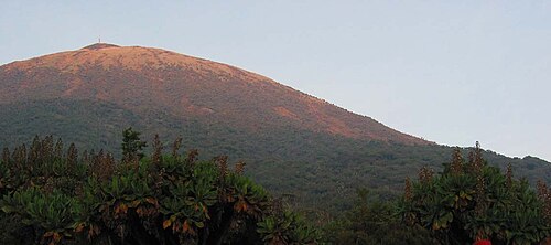
⛰️ Highest Elevation
- Map Locations: Google Maps | OpenStreetMap